
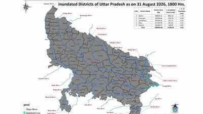
LUCKNOW: Rivers in Uttar Pradesh reached or crossed danger levels at several monitoring stations as satellite data showed inundation of 11,358.49 hectares across five districts, highlighting the spread of flood conditions in the state. The affected districts are Ballia, Ghazipur, Gorakhpur, Mau and Deoria.The inundation figures were released by the Flood Management Information System Centre (FMISC) under the Uttar Pradesh irrigation department. Its satellite-based assessment, prepared using RISAT-1A MRS SAR data analysed by the National Remote Sensing Centre, showed major inundation in Ballia and Ghazipur and minor inundation in Gorakhpur, Mau and Deoria by Monday evening.Ballia reported flooding in 179 villages across 12 blocks, covering approximately 8,061.63 hectares. Ghazipur saw inundation in 87 villages across six blocks, covering 2,341.33 hectares. Deoria reported flooding in 18 villages across five blocks, Gorakhpur in 14 villages across three blocks, and Mau in 13 villages in one block.The combined assessment covered 311 villages in 27 blocks. The total submerged area was estimated at 11,358.49 hectares.The FMISC clarified that the assessment includes riverine flooding, water accumulation in low-lying areas, rainfall-induced flooding and isolated waterlogged patches.According to the Central Water Commission’s readings available at 9 pm on Tuesday, water levels were at or above the danger mark at 11 monitoring stations in Uttar Pradesh. The situation was serious along the Ganga, Ghaghra and their tributaries in Budaun, Barabanki, Ballia, Mirzapur, Varanasi and Ghazipur.At Kachhla Bridge in Budaun, the Ganga was flowing at 162.43 m, exactly at the danger level. Its warning level is 161.80 m.In Barabanki, the Ghaghra at Elginbridge was flowing at 106.09 m, 2 cm above its danger mark of 106.07 m and more than a metre above the warning level of 105.07 m. The CWC forecast suggested that the river could rise further to 106.07 m by 9 am on Wednesday.The Sharda also known as Mahakali river at Kukea in Lakhimpur Kheri rose to 139.81 m, marginally above its danger level of 139.8 m and well above the warning level of 138.8 m.The Ghaghra was also above the danger mark at Turtipar in Ballia, where it stood at 64.08 m against a danger level of 64.01 m. The station recorded 22 mm rainfall during the day. The forecast, however, indicated a fall to 64 m by Wednesday morning.In Ballia, the Ganga was flowing at 59.37 m, nearly 1.75 m above its danger level of 57.615 m. The district accounted for the largest share of the inundated area recorded by the state’s FMISC.The most pronounced river-level exceedances in eastern Uttar Pradesh were recorded along the Ganga and its tributaries. At Tendui in Varanasi district, the Varuna was flowing at 71.35 m against a danger level of 70.21 m. The station recorded 43 mm rainfall.At Saidpur in Ghazipur, the Ganga stood at 67.52 m against a danger level of 67.19 m. The station recorded 68 mm rainfall. At the Ghazipur monitoring station, the river was flowing at 63.33 m, exceeding the danger level of 63.105 m. The level was rising and was forecast to reach 63.47 m by 8 am on Wednesday. The station recorded 63 mm rainfall.In Mirzapur, the Ganga was above the danger mark at Ahraura and Chunar. At Ahraura, the river stood at 74.75 m against a danger level of 74.30 m, though the trend was declining. At Chunar, it was flowing at 72.82 m against a danger level of 72.78 m.
Share your thoughts in the comments
Be respectful · TOI community guidelines
At Narayanpur in Mirzapur, the Ganga was at 72.59 m, above the warning level of 71.41 metres but 21 cm below the danger mark of 72.41 m. The station recorded the highest rainfall among the locations shown in the CWC data, at 75.4 mm.The CWC data also recorded a high level at Chausa in neighbouring Bihar, where the Karamnasa was flowing at 61.86 m against a danger level of 60.39 m. The reading is significant for the downstream flood situation in eastern Uttar Pradesh.“The readings suggest that flood pressure is spread across multiple river systems rather than being confined to one stretch. While some stations showed a declining trend, water levels at several locations remained above danger marks, leaving riverbank settlements, agricultural fields, roads and embankments vulnerable,” said an official source.